
Magnetometer surveying is a geophysical method used to detect and map variations in the Earth's magnetic field caused by buried ferrous (iron-containing) objects and geological features. By measuring subtle magnetic anomalies, magnetometers can accurately locate underground metallic targets without the need for excavation. Magnetometer systems are widely used in mining, environmental investigations, archaeological surveys, utility locating, and unexploded ordnance (UXO) detection. When integrated with UAV platforms and high-accuracy GNSS positioning, they enable rapid, safe, and efficient data collection over large or difficult-to-access areas while delivering precise, georeferenced results. At Advantage Drones. we provide advanced magnetometer solutions that combine industry-leading sensor technology with professional survey workflows and data processing. Our systems deliver high-quality magnetic data that supports informed decision-making, improves operational efficiency, and reduces the time and cost associated with traditional ground surveys. Whether you're searching for buried infrastructure, conducting mineral exploration, mapping archaeological sites, or identifying underground metallic objects, our magnetometer solutions provide reliable data you can trust.
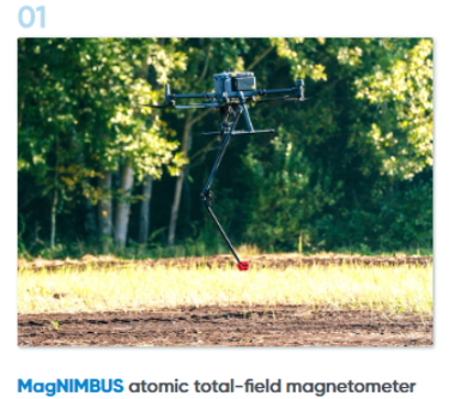
MagNIMBUS is a high-performance atomic total-field UAV magnetometer system designed for professional geophysical surveys. By measuring subtle variations in the Earth's magnetic field, it enables the detection of buried ferrous and non-ferrous objects with exceptional accuracy.
Applications Include:
-
Mineral & Resource Exploration – Detect magnetic anomalies to assist in identifying potential mineral deposits and support resource exploration programs.
-
Geological Mapping – Produce detailed magnetic datasets for mapping geological structures, faults, and lithological boundaries.
-
Archaeological Investigations – Locate and map buried archaeological features while minimising disturbance to sensitive sites.
-
UXO (Unexploded Ordnance) Detection – Support the detection and mapping of unexploded ordnance to improve safety during remediation and land development projects.
-
Environmental & Contamination Surveys – Identify buried metallic debris and support environmental assessments, remediation planning, and contaminated site investigations.
-
Buried Infrastructure Investigations – Locate underground pipelines, utilities, cables, tanks, and other buried infrastructure for construction, maintenance, and asset management.
MagNIMBUS delivers survey-grade magnetic data while significantly reducing field time compared to traditional ground surveys. When integrated with SkyHub, all measurements are accurately synchronised with GNSS positioning for reliable post-processing and high-resolution magnetic mapping.
For More Information

SENSYS MagDrone R1 is a lightweight fluxgate UAV magnetometer system designed for efficient magnetic surveys where portability and rapid deployment are essential. It provides reliable magnetic measurements for a wide variety of engineering, environmental and archaeological applications.
Applications Include:
-
Utility Locating – Detect and map underground utilities, pipelines, cables, and other buried infrastructure to support construction, maintenance, and asset management.
-
Archaeological Surveys – Identify and map buried archaeological features and historical remains with minimal ground disturbance.
-
Environmental Investigations – Support environmental assessments by locating buried metallic objects, waste, and other subsurface features.
-
Engineering Site Assessments – Provide valuable subsurface information for site investigations, infrastructure planning, and geotechnical studies.
-
Buried Metal Detection – Locate ferrous and non-ferrous metallic objects beneath the ground for engineering, environmental, forensic, and remediation applications.
The compact design makes the MagDrone R1 ideal for surveying confined areas while maintaining excellent flight performance. Combined with SkyHub, magnetic data is precisely georeferenced for accurate interpretation and reporting.
For More Information

SENSYS MagDrone R3 is an advanced fluxgate UAV magnetometer system developed for professional magnetic surveys requiring increased sensitivity and survey efficiency. It is capable of detecting buried metallic objects and geological anomalies with high accuracy.
Applications Include:
UXO Detection – Assist in locating and mapping unexploded ordnance (UXO) to improve site safety and support remediation activities.
-
Buried Pipelines & Utilities – Detect and map underground pipelines, utility networks, and other buried infrastructure for construction, maintenance, and asset management.
-
Archaeological Investigations – Identify and map buried archaeological features and historical sites while minimising ground disturbance.
-
Geological Exploration – Collect high-resolution geophysical data to support geological mapping, mineral exploration, and resource assessment.
-
Environmental Surveys – Support environmental monitoring and site investigations by identifying buried metallic objects and subsurface features for remediation and land management.
The MagDrone R3 provides higher survey performance than entry-level systems, making it an excellent solution for organisations requiring detailed magnetic mapping across larger project areas while reducing operational costs.
For More Information

SENSYS MagDrone R4 is a multi-sensor fluxgate UAV magnetometer system engineered for high-resolution magnetic mapping and advanced geophysical investigations. Featuring five fluxgate sensors, it provides exceptional target resolution and survey efficiency for demanding applications.
Applications Include:
-
Searching for UXO (Unexploded Ordnance) – Detect and map unexploded military ordnance to improve site safety and support remediation projects.
-
Locating Buried Infrastructure – Identify underground pipelines, cables, utilities, and other metallic infrastructure for construction, maintenance, and asset management.
-
Archaeological Investigations – Discover and map buried archaeological features while minimising ground disturbance.
-
Mineral Exploration – Detect magnetic anomalies associated with mineral deposits to support exploration and resource evaluation.
-
Detection of Buried Metallic Objects – Locate ferrous and other metallic objects beneath the surface for environmental, engineering, and forensic applications.
-
Engineering & Environmental Surveys – Provide high-resolution geophysical data for site investigations, infrastructure planning, contamination assessments, and environmental monitoring.
The MagDrone R4 is ideal for projects requiring maximum sensitivity and detailed magnetic imaging. With five sensors operating simultaneously, it can detect smaller buried targets while covering large areas efficiently, making it one of the most capable UAV magnetometer systems available.
For More Information

Geometrics MagArrow Mk2 is a lightweight cesium vapour UAV magnetometer designed for ultra-high sensitivity airborne magnetic surveys. Its industry-leading performance allows the detection of extremely small magnetic anomalies, making it ideal for precision geophysical investigations.
Applications Include:
-
Mineral Exploration – Identify geological structures and magnetic anomalies to support mineral prospecting and resource exploration.
-
Geological Mapping – Collect high-resolution geophysical data for geological interpretation, fault mapping, and terrain analysis.
-
Archaeological Surveys – Detect and map buried archaeological features and historical sites with minimal ground disturbance.
-
UXO Detection – Assist in locating unexploded ordnance (UXO) and other ferrous objects to improve site safety and planning.
-
Environmental Investigations – Support environmental assessments by identifying buried features, contamination boundaries, and geological variations.
-
Pipeline & Infrastructure Detection – Locate underground pipelines, utilities, cables, and other infrastructure for asset management, construction, and maintenance projects.
The MagArrow Mk2 delivers exceptional data quality while maintaining a lightweight UAV payload. When integrated with SkyHub, all magnetic measurements are synchronised with precise GNSS positioning, producing highly accurate georeferenced datasets for professional interpretation and analysis.